CanAlaska reports summer program for West McArthur Uranium Project
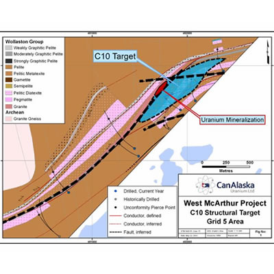
Map of the West McArthur uranium project. — Photo courtesy CanAlaska Uranium Ltd. CanAlaska Uranium Ltd. (TSX-V: CVV; OTCQB: CVVUF; Frankfurt: DH7N
Map of the West McArthur uranium project. — Photo courtesy CanAlaska Uranium Ltd.
CanAlaska Uranium Ltd. (TSX-V: CVV; OTCQB: CVVUF; Frankfurt: DH7N), ("CanAlaska" or the "Company") is pleased to report ongoing summer work under Cameco's year 3 work program at the 5 kilometre long Grid 5 target area at the 36,000 ha West McArthur uranium project.
Key Points:
- Winter drill holes show uranium halos and possible target over-shoot
- Summer geophysics-borehole survey to locate conductor missed in hole WMA050
- 3D modeling of complex geology where C10 fault cuts across stratigraphy
Cameco's work has been focused on evaluating the C10 corridor, which is highlighted by the NE-striking conductivity high in the southern part of the property. Work to date has been focused around the northeastern part of that corridor where several ground-defined conductive responses of varying strength were identified. The summer activities for 2018 include borehole EM on Line 6000W to explain/locate the conductor and better interpret the fault location.
Seven diamond drill holes were completed throughout the winter program, for a total of 6,926 metres. Based on the new drilling information, one branch of the C10 fault is now interpreted to cut across the basement stratigraphy west of the eastern property boundary, continuing at an easterly strike, whereas the stratigraphy is interpreted to bend to a more northeasterly striking orientation as mapped by the airborne ZTEM survey.
To date, three holes have intersected mineralization, up to a maximum of 1.51% U3O8 over 5.5 metres. The main anomalous zone is centered on the structural complexity observed along the L5700W and L6000W geophysical lines, and is roughly the current extent of the 1 ppm uranium halo in the medial to lower sandstone.
Drill hole WMA044 targeted the down dip projection of a fault in the medial sandstone column of WMA042/42-2 and associated with a broad zone of anomalous uranium geochemistry extending over 200 metres vertically. Weakly elevated uranium geochemistry (>1 ppm) is present over much of the lower 250 metres of the sandstone column in WMA044. The uranium geochemistry in WMA045 and WMA046, completed 300 metres along strike to the east, also returned intermittent uranium values above 1 ppm present in composite samples throughout the lower 400-550 metres of the sandstone column. The anomalism in the upper-medial sandstone of WMA045 could be related to another easterly striking fault to the south or a nearby cross-cutting structure.
The C10 North conductor was tested with drill hole WMA050, near the eastern property boundary but did not explain the targeted conductive response. No structure or hydrothermal alteration is observed in the lower sandstone column, however a discrete fracture zone was intersected in the medial sandstone column, followed by 80 metres of patchy weak sooty pyrite coincident with weakly anomalous uranium geochemistry.
WMA046 tested the interpreted C10 conductor with an aggressive step-out, 600 metres along strike to the southwest of WMA042/042-2. The hole is interpreted to have overshot the conductor.
WMA049-1, which tested a second EM pick 250 metres to the south on the same section, intersected a five metre wide chlorite and clay-altered semi-brittle fault 20 metres below the unconformity.
WMA047, 800 metres southwest of WMA046 intersected several narrow faults in the sandstone column, coincident with silicification and dravitic clay. These appear to project back to an EM response to the southeast although likely that it overshot more conductive lithologies
President Peter Dasler commented, "We have a series of uranium targets at Grid 5. The geological complexity, depth to target, and geophysical data resolution make area challenging to explore, however the Cameco team has a new geological interpretation and we believe that they are closing in on the most promising targets. The structural complexity along the C10 fault system is encouraging for structural uranium traps and the widespread geochemical anomalism emphasizes the movement of fluid in the sandstone column, and the potential for a significant uranium deposit in this area."
The qualified technical person for this news release is Dr Karl Schimann, P. Geo, CanAlaska director and VP Exploration.
CanAlaska Uranium Ltd. (TSX-V:; OTCQB: CVVUF; Frankfurt: DH7N) holds interests in approximately 102,870 hectares (254,000 acres), one of the largest land positions in Canada's Athabasca Basin - the "Saudi Arabia of Uranium." CanAlaska's strategic holdings have attracted major international mining companies. CanAlaska is currently working with Cameco and Denison at two of the Company's properties in the Eastern Athabasca Basin. CanAlaska is a project generator positioned for discovery success in the world's richest uranium district. For further information visit www.canalaska.com.
